


lac petarel

mthomas30
User
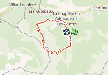

Length
15.9 km

Max alt
2468 m

Uphill gradient
1231 m
Km-Effort
32 km

Min alt
1264 m

Downhill gradient
1232 m
Boucle
Yes
Creation date :
2020-08-04 09:39:05.06
Updated on :
2020-08-05 07:24:11.489
7h07
Difficulty : Medium

FREE GPS app for hiking
 SityTrail
IGN / Geographical institutes
SityTrail Plus
The world is yours!
About
Trail Walking of 15.9 km to be discovered at Provence-Alpes-Côte d'Azur, Hautes-Alpes, La Chapelle-en-Valgaudémar. This trail is proposed by mthomas30.
Positioning
Country:
France
Region :
Provence-Alpes-Côte d'Azur
Department/Province :
Hautes-Alpes
Municipality :
La Chapelle-en-Valgaudémar
Location:
Unknown
Start:(Dec)
Start:(UTM)
278560 ; 4964363 (32T) N.
Comments